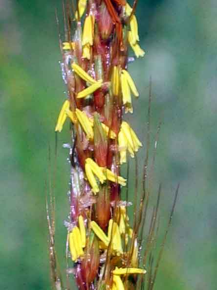
Blackland Prairie is a special mixture of soil and mineral deposits that distinguishes the blackland ecosystem from other prairie and woodland types and supports its diverse array of plant and animal species. Described as “black velvet” when freshly plowed and moistened from a good rain, true blackland soils are deep, dark, calcareous deposits renowned for their high productivity. Scientists believe the richness of the prairie soils is derived from the abundant invertebrate fauna and fungal flora found in the soils themselves. Dominant native grasses of the original prairie included Big Bluestem (Andropogon gerardii gerardii), Switch Grass (Panicum virgatum), Little Bluestem (Schizachyrium scoparium), and Indian Grass (Sorghastrum nutans). Several rare plant species are found on some of the prairies, including purple beard tongue (Penstemon cobea), and eared false foxglove (Tomanthera auriculata) in the Blackland Prairie of Arkansas. Steigman’s crayfish (Procambarus sub geiardiella steigmani) is found on some larger prairies in North Central Texas. R.C. Anderson writes that the eastern prairies and grasslands “would mostly have disappeared if it had not been for the nearly annual burning of these grasslands by the North American Indians.” In the West, as well, Indian burning also greatly extended the area of grasslands and reduced the area of forest. Indian camp sites near Spring Creek (3 locations) were Caddo or Wichita and are considered to be pre-Columbian. Wichita Indians and other Southern Plains Indians didn’t seem to venture into this area until Europeans began pushing them south. If the sites were indeed left by Caddo Indians, then they might have been Anadarkos. Anadarkos were the member tribe of the Caddo Confederacy that was most likely to be found in NE Dallas County.
One of nicest public prairies is Parkhill Prairie, located in Collin County nw of Farmersville, Texas off County Road 622 east of US 78. Work was done to restore 30 acres to add to the existing 52 acres of undisturbed blackland prairie during the late 1980’s. This project was funded by a cooperative effort of the voters of Collin County, Texas Parks and Wildlife, and the Texas Nature Conservancy. Parkhill is maintained under the Collin County Open Space Program by the Heard Museum. In Texas, the Blackland Prairies are the rarest of all the prairie types, with less than 3,000 acres preserved out of a historical total of 12 million acres.
The Nature Conservancy manages several prairies in North Central Texas, but you must ask for permission or a guide. (contact Jim Eidson, Texas Nature Conservancy – he is the steward for the Texas Nature Conservancy’s Clymer Meadow an 800-acre remnant prairie near Celeste, Texas. Some of his restoration techniques include prescribed burns, re-establishment of native forbs and grasses, invasive plant control, and bison grazing.). There are several other prairies and associated riparian woodlands that Jim manages in North Central Texas, including a recent rare Eastern Gammagrass prairie
Parkhill Prairie June 11, 2003 Dickcissels were singing during mid-day, and we heard Painted Buntings in the small patches of forest. Observed Blue Grosbeaks, Lark Sparrows, and Scissor-tailed Flycatchers..
Directions to Parkhill Prairie: Take Texas 78 north from Dallas to US 380, then east on 380 for about six miles.
Turn north on FM 36 for nine miles, then west on County Road 1130 for one mile to entrance. Alternate Route: Take US 78 north of Farmersville to CR622 (gravel road) to Arnold, turn right on CR 668 and then continue east across Arnold Creek, until you reach the top of the hill….the entrance will be on your left.
Here’s what’s happening to much of the remaining Blackland Prairie…..urbanization and development of old farmland and ranches and a few intact native prairies…

Cranes signal more native prairie scraped and paved for industrial development in Richardson, Texas (spring 2005). The new T.I.Plant eventually closed when jobs went to China.
Gilgai – An interesting topographic soil feature can be found in Blackland Prairie vertisols and in places such as Australia
and Africa. Gilgai can be defined as ” The microrelief of soils produced by expansion and contraction caused by changes in moisture. Gilgai is found in soils that contain large amounts of clay, which swells and shrinks noticeably with wetting and drying.
It usually occurs as a succession of microbasins and microknolls in nearly level areas or as microvalleys and microridges parallel to the direction of the slope.” Source ( Canadian Soil Information System CanSIS ).
Some of the larger gilgai store significant amounts of water and can develop wetland vegetation and associated biota, including amphibians, particularly gilgai found in forested regions of the Gulf Coastal Plain. We have found Sedge Wrens at one gilgai site in Sachse, Texas. Unfortunately, although gilgai contribute to sustained streamflows and improved water quality they are not protected by the Clean Water Act. They are, in fact, largely ignored and remain obscure in the scientific world.
Below: Aerial map of a 10-acre gilgai feature within the city limits of Sachse, Texas located a few miles northeast of Spring Creek Forest. This represents a rare vertisolic gilgai prairie remnant which we discovered using the recent availabilityof Google Earth. Further exploration has revealed literally dozens of gilai complexes around Lake Ray Hubbard
.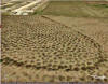
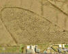

The feature is readily seen at an eye altitude of approximately 1400 feet. The features seem to persist even if the original prairie has been converted to range or other land use. USDA NRCS digitized soil maps can be consulted to determine how consistent these features are tied to specific soil series.
The larger streams historically had mature bottomland hardwood forests. ” Just south of downtown Dallas lies more than 6,000 acres of urban wilderness: the Great Trinity Forest, the largest urban bottomland hardwood forest in the nation. The Great Trinity forest is a world unto itself and home to an estimated 1,300 species of plants and animals, including two types of endangered birds… Each season, the forest communicates all the splendor and detail that nature has to bestow. In winter, the forest hibernates in the quiet of cold, dusted by an occasional flurry of snow unblemished by footprints. Spring erupts with green, laced with the color of wildflowers, a visual feast of life and new growth. In summer, the sun filters through leaves and branches as the forest floor soaks in warmth.
When autumn comes, the plentiful leaves from countless trees fall lazily to the earth to form a blanket of nourishment,feeding the soil, nature’s life cycle preparing for spring. Here in our midst, within our reach, is a wonder of nature. ”
1 Kim Ritzenthaler/ The Dallas Morning News, February 2, 2002.
A good web reference to prairies can be found at the following website: http://www.tarleton.edu/~range/Home/home.htm
which documents range types of North America, including tallgrass, tallgrass savannah, shortgrass, and true prairies. A
good link for identifying native Texas grasses is at this Tracy Herbarium web site: Texas Grasses,
http://www.csdl.tamu.edu/FLORA/taes/tracy/610/ Also refer to the Links page for additional information.
White Rock Lake Prairie Remnants.. first photo below is located uphill of of the Norbuck Park parking lot sw of Mockingbird and Buckner. The second photo is on Flagpole Hill, another 2-acre remnant prairie. The photos were taken early morning on October 30th, so the little bluestem appears dark. Notable grasses include Old field three awn, Indian Grass, Big Bluestem, Little Bluestem, and Meadow Dropseed. White Rock Lake has several other small patches of prairie generally located on the upper elevations on the ne side of the Lake. There is another good size prairie located in Harry Moss Park southwest of the intersection of Arborside Drive and Royal Lane. This area is also called Fair Oaks Park on some maps.
Dallas County Preserves – some of the Preserves have remnant tallgrass prairies.
