Walking Trails for Spring Creek Preserve and Greenbelt
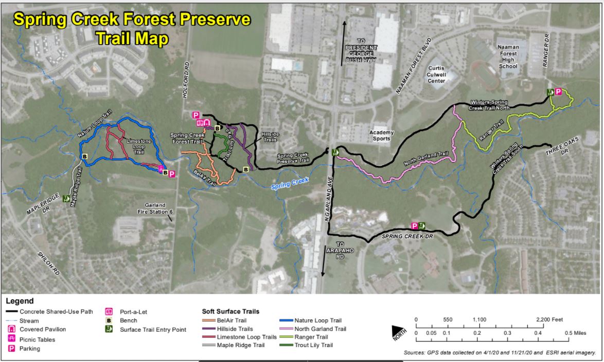
Trailhead locations:
Halff Park Trailhead, 4695 Ranger Drive, Garland TX 75040
Note: There are additional access points behind Curtis Culwell Center and at North Garland Avenue, but parking is limited.
The natural-surface trails take you through the tallest trees and wildest part of the Preserve.
-
- Winters-Spring Creek Trail North (WSCTN) – 0.87 mile – A paved, multi-use trail from the trailhead at the parking lot just east of Ranger Drive, extending to North Garland Avenue.
- Ranger Trail (RgT) – 0.55 mile – a natural-surface trail from Ranger Drive Trailhead at Halff Park to Culwell Center. Explore the crucial ecological benefits of the natural swale (low area) between the NFHS sports complex and Spring Creek.
- North Garland Trail (NGT) – 0.74 mile – a natural-surface trail from Culwell Center to North Garland Avenue. The wildest area of the Preserve, with creekside hiking through the unspoiled riparian hardwood forest for which the Preserve is famous.
- An Eagle Scout project added signs to the natural surface trails between Halff Park and North Garland Avenue. Signs on carsonite posts provide hikers with directional information, 911 locators in case of emergency, and a QR code that directs hikers digital device to the Society’s Trails Map web page.
Lee F. Jackson Spring Creek Forest Preserve Trailhead, 1770 Holford Road, Garland, TX 75044
Enjoy the dappled light of trails that take you through the forest understory. Also find small, unspoiled meadows reminiscent of the Blackland Prairie that once dominated a large swath of Texas with native wildflowers and grasses.
-
- Spring Creek Preserve Trail (SCPT) – 0.62 mile – A paved, multi-use trail from the trailhead at the parking lot at 1770 Holford Road to North Garland Avenue.
- Spring Creek Forest Trail (SCFT) – 0.24 mile – A paved trail from SCPT to the overlook at Spring Creek.
- Hillside Trails (HsT) – 0.34 mile – All natural-surface trails west of North Garland Ave. and east of concrete trail to the creek.
- Trout Lily Trail (TLT) – 0.13 mile – A natural-surface trail to the popular Trout Lilies (Erythronium albidum) of Spring Creek Forest Preserve. The lilies are abundant throughout this section of the Forest during the month of February.
- BelAir Trail (BAT) – 0.57 mile – All natural-surface trails west of concrete trails to the creek but east of Holford Road. Ponder how this 1959 Chevrolet BelAir (Impala?) came to rest within uncut riparian hardwood forest with oaks, elms, pecans, and occasional black walnuts. Marvel at the diverse understory that helps to make this ecosystem so unique.
Spring Creek Park Preserve Trailhead, 1787 Holford Road, Garland, TX 75044
Here you can easily experience two ecosystems – an expansive prairie with all its native flowers and grasses and a great riparian forest as it grows along Spring Creek.
-
- Nature Loop Trail (NLT) – 0.82 mile – The primary natural-surface outer loop trail that begins and ends at the parking lot. One of the Preserve’s most popular trails; hosts the Self-Guided Interpretive Nature Trail, which offers a peek at the diverse habitats in the preserve.
- Limestone Loop Trails (LLT) – 0.37 mile – Natural-surface inner loop “prairie” trails. Hikers can cross the Preserve’s distinctive limestone wildflower prairie, with Missouri primrose, New Jersey tea, and countless other native Texas wildflowers. This area is a pollinators’ paradise, featuring butterflies, native solitary bees, and many, many more.
- Mapleridge Trail (MRT) – 0.13 mile – Natural-surface trail from Mapleridge Drive, connecting to the NLT. Limited on-street parking leads to this backdoor route into the park preserve.
Winters Park Trailhead, 1419 Spring Creek Drive, Garland, TX 75044
-
- Winters-Spring Creek Trail South (WSCTS) – 0.67 mile – A paved, multi-use trail from the trailhead at the parking lot at Winters Park playground to trailhead (access point) at 3 Oaks Drive.
Trailhead not yet on the above Trail map:
Spring Creek Greenbelt – Fred Harris Section, 6006 North Shiloh, Garland, TX 75040
-
- A paved, multi-use trail – about one mile round-trip. From the parking lot, the trail loops under the Shiloh bridge and around a scenic little pond. Although the pond may dry out in the summer heat, it is still a great spot for both walking and birding.
- Playground and Picnic tables
For more details, see the City of Garland Trails and Bikeways Master Plan at
http://garlandparks.com/3665/Trails-and-Bikeways-Master-Plan.